The Zenpukujigawa river 善福寺川(ぜんぷくじがわ) is a personal favorite: lush, quiet, and slightly wild, though not as wild as when it regularly flooded the surrounding area. The river has since been “tamed”, being placed in the cement walls typical of Tokyo rivers (and subject to river engineering 河川工学). But sections of the river are lined by parks, giving the river a tranquil atmosphere not found in some other Tokyo rivers.
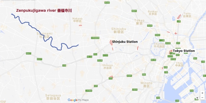
- River source: Zenpukuji pond 善福寺池 (map)
- End: confluence with the Kandagawa (map)
- Length: ~10.5 to 11.0 km
- Location: the southern portion of Suginami 杉並区, Tokyo
Features:
- 和田堀公園 Wadaborikōen / Wadabori koen / Wadabori Park (map); shown below is a baseball field that also doubles as flood overflow storage.

Maps (the “You are here” is centered here: Google Maps):
- Zenpukujigawa River Green Area Administration Office in Tokyo 東京都善福寺川緑地管理所
- Zenpukujigawa River jogging course guide map 善福寺川ジョギングコース案内図


Photos from the river:


Resources:

[…] Zenpukujigawa river 善福寺川 also drains into the […]
LikeLike
[…] 武蔵野園 / 釣り堀 武蔵野園 / ツリボリムサシノエン sits on a bend of the Zenpukijigawa river that is particularly lush due to the river’s history of flooding and natural shape. Look […]
LikeLike
[…] This danchi is close to a beautiful bend of the Zenpukujigawa river. […]
LikeLike
[…] How to go to Zenpukujigawa river 善福寺川 by […]
LikeLike
[…] can also unleash their excess water on tennis courts, as seen in these two examples from the Zenpukujigawa 善福寺川 (map 1, map 2) and one from the Nogawa 野川 (map 3). Just like a bathtub, the riverbanks have […]
LikeLike
[…] (R4) Zenpukujigawa river 善福寺川 […]
LikeLike
[…] along the Zenpukujigawa 善福寺川 this weird and windy Sunday, I was reminded just how close we are to spring. It was […]
LikeLike
[…] danchi is located near the confluence of the Zenpukujigawa river 善福寺川 and the Kandagawa […]
LikeLike
[…] danchi is located near the confluence of the Zenpukujigawa river 善福寺川 and the Kandagawa […]
LikeLike
[…] danchi map; (2) a view with the neighboring park in the foreground; to the left of the park is the Zenpukujigawa river 善福寺川; (3) Ogikubo 2-chome Apartments from the air, with south at […]
LikeLike
[…] And there are over 100 small and mid-sized rivers and canals such as the Kanda, Meguro, and Zenpukujigawa rivers, all part of a larger river system; the Tamagawa and Arakawa river systems are each […]
LikeLike
[…] Zenpukujigawa river 善福寺川 (formerly prone to flooding, which has since been straightened) […]
LikeLike